Aïr Mountains
| Aïr Mountains (Ayar, Azbin, Abzin) | |
| Aïr Massif, Ayr | |
| Range | |
 Satellite image, showing the Aïr Mountains in the central north part of Niger.
|
|
| Country | Niger |
|---|---|
| Region | Agadez Region |
| Highest point | |
| - elevation | 2,022 m (6,634 ft) |
| Area | 84,000 km² (32,433 sq mi) |
| UNESCO World Heritage Site | |
| Name | Air and Ténéré Natural Reserves |
| Year | 1991 (#15) |
| Number | [1] 573[1] |
| Region | Africa |
| Criteria | vii, ix, x |
The Aïr Mountains (also known as the Aïr Massif or Air of Niger; the name is Ayăr in Tuareg and Azbin /Abzin in eastern / western Hausa) is a triangular massif, located in northern Niger, within the Sahara desert. Part of the West Saharan montane xeric woodlands ecoregion, they rise to more than 6,000 ft (1 830 m) and extend over 84 000 km².[2] Lying in the midst of desert north of the 17th parallel, the Aïr plateau, with an average altitude between 500 and 900 m, forms an island of Sahel climate which supports a wide variety of life, many pastoral and farming communities, and dramatic geological and archaeological sites. There are notable archaeological excavations in the region that illustrate the prehistoric past of this region.[3] The endangered Painted Hunting Dog, Lycaon pictus once existed in Air of Niger region, but may now be extirpated due to human population pressures in this region.[4]
Contents |
Geology
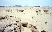
The Precambrian Aïr Mountains consist of peralkaline granite intrusions which appear dark in colour (unusual since most granitic masses are light-toned in the field). In the Sahara Desert such mountains often stand out in stark relief as topographic heights amidst lowlands covered by sand. [5] The terrain consists of high plateau, mountain ranges, and broad, sandy valleys and seasonal wadis which once contained rivers. Areas of these deep, often intersecting, valleys also contain waterborne clay and silt deposits. Underground watercourses in some of these valleys continue to provide year round oasis and seasonal vegetation.
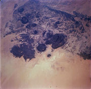
The Aïr mountains themselves consist of nine almost circular massifs rising from a rocky plateau, bordered by the sand dunes and plain of the Ténéré Desert to the east.
The massif is a plateau consisting of a Cambrian age erosion surface on Precambrian metamorphic rocks, punctuated by a series of flat-topped, granite intrusion peaks, which include Mont Idoukal-n-Taghès (Niger's highest point at 2022 m),[6] Mont Tamgak (1988 m), Mont Greboun (1944 m),[7] Adrar Bous, Fadei, Chirriet, Taghmert, Agueraguer, Takaloukouzet, and Goundai.
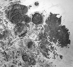
The massif contains volcanic features includong the extinct caldera of Arakao, Cenozoic lava flows of hawaiite to trachyte composition, volcanic cones, tuff rings and one of the largest ring dike systems in the world.[8]
At Izouzaoenehe, lie the marble Blue Mountains, and the lower Zagado valley is surrounded by white marble hills.
Climate
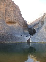
The Guelta near the town of Timia in central Aïr provides year round water in an otherwise dry region.
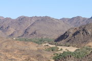
The valley around the town of Timia remains green through irrigation, ground water collected in rocky pools, and rain water channeled down the gravel bottomed Wadis.
|
Because of its altitude (on average between 500 and 900 m) and despite its low rainfall (50 to 160 mm/year on the lower plateau), the Aïr forms a green region in comparison with the surrounding deserts, especially after the August-September seasonal rains. The climate is classified as Sahel, like that of the regions well to its south. While the mountains are largely bare of vegetation, the dry wadi river valleys (known by the Hausa term "Kori") channel and hold rainwater in gueltas (stone pools, such as that near the town of Timia), creating oases which provide forage for animals, and in some areas, farming. The high Bagzane plateau of the central Aïr in particular provides adequate rainfall for intensive agriculture. Other, vast, areas of the region are entirely devoid of plant life and with their volcanic protrusions and rock fields present an otherworldly appearance.
Population
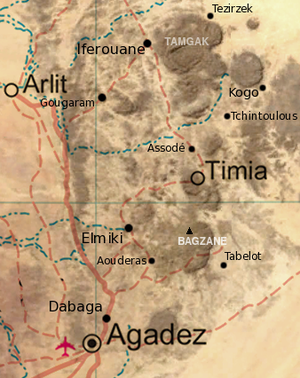
The town of Agadez in the heart of the Tuareg country is the capital of Aïr. Much of the Tuareg population of Aïr until recently led a nomadic life, relying essentially on camel and goats from which they take milk, meat and skins used in the production of local handicrafts. Most sedentary populations were either dependents of higher cast Tuareg pastoralists or the Ikelan ( Bouzou in Hausa / Bella in Songhai), former slaves and captives of the Tuareg from Hausa and other southern peoples. These peoples were settled in northern oases, to tend the date palm plantations held by the noble clans.
Agriculture products from oases such as Timia, Aouderas and Tabelot are traditionally exchanged against clothes, or salt, brought by camel caravans (Azalai) from the remote Tenere oases of Bilma and Fachi to the east.
History
The Aïr is known for its rock art, dating from 6000 BC to around AD 1000. During the Neolithic Subpluvial the region was a pastoral area, as is illustrated by images of cattle and large mammals. During the 3rd millennium BC, however, a process of desertification began and the Tuareg from further north migrated into the region. Later art indicated war, depicting horses and chariots. In particular, a five-meter-high carving of a giraffe at Dabous discovered in 1999 is internationally famous. Cave art in the region is predominantly stone carving, initially with sharp rock, and from around 1200 BC perhaps with metal. [9]
When the Tuareg tribes were pushed south by Arab invaders in the eighth and ninth centuries, there were Gobirwa Hausa in the southern Aïr. Successive Tuareg Tels have controlled the area since at least the twelfth century. Agadez, as well as In-Gall to the east, were the farthest outposts of the Songhai Empire in the early 15th century. In the sixteenth century the area fell under the newly created Tuareg Sultanate of Aïr, and remained so until the arrival of the French at the end of the 19th.
The emergence of the French weakened the Tuareg Kels and provoked both infighting and resistance to colonialism. From the 1880s, Toubu raids increased, and when the Tuareg Ag Mohammed Wau Teguidda Kaocen rose against the French in 1917, many towns were destroyed on his way to the siege of Agadez. When the French retook Agadez, a brutal punitive expedition through the Aïr left many formerly populous places abandoned, razed by Kaosen and the French successively. [10]
While the Kel Owey continued to dominate the settled oasis towns and pastoral herding, the sedentary farmers (Tuareg, Hausa, or Songhai) expanded farming and sedentary livestock cultivation in the mid 20th century.
The famines of the 1970s and 1980s brought an end to this expansion, and as Agadez and Arlit grew, the towns of the Aïr have shrunk. The Tuareg Rebellion of the 1990s saw brutal government reprisals which depopulated many villages in the Aïr. Peace from the mid 1990s, as well as the uranium mines of Arlit brought unprecedented growth to the region, with many small towns gaining valuable tourism revenue. In 2004, a locust invasion ravaged many gardens, bringing scarcity and contributing to the Second Tuareg Rebellion (beginning in 2007) which continues to plague the region, effectively ending the nascent tourist industry. [11]
References
- ↑ Air and Ténéré Natural Reserves - UNESCO World Heritage Centre
- ↑ Thorp, M.B. 1969: Some aspects of the geomorphology of the Air Mountains, southern Sahara. Transactions, Institute of British Geographers, 47, 25–46.
- ↑ Thurstan Shaw, Paul Sinclair, Bassey Andah and Alex Okpoko. 1995. The Archaeology of Africa: Food, Metals and Towns, Published by Routledge, ISBN 041511585X, 9780415115858 857 pages
- ↑ C. Michael Hogan. 2009. Painted Hunting Dog: Lycaon pictus, GlobalTwitcher.com, ed. N. Stromberg
- ↑ [rst.gsfc.nasa.gov/Sect17/Sect17_3.html Use of Remote Sensing in Basic Science Studies], Section 17, NASA/Primary Author: Nicholas M. Short, Sr. (Site last updated: June 18, 2007).
- ↑ Peakbagger, Mont Bagzane, Niger: incorrectly calls peak Mont Bagzane. Name of the peak is "Idoukal-n-Taghès", part of the plateau named "Bagzane". Also note, official and international sources believed Mont Greboun to be the highest peak as late as 2001.
- ↑ Peakbagger, Mont Greboun, Niger.
- ↑ Paul D. Lowman Jr. VolcanoWorld: Air, Niger. North Dakota and Oregon Space Grant Consortia, administered by the Department of Geosciences at Oregon State University.
- ↑ Trust for African Rock Art. ROCK ART OF SAHARA AND NORTH AFRICA:THEMATIC STUDY. David COULSON. Sub-Zone 3: Niger (June 2007).
- ↑ Jolijn Geels. Niger. Bradt London and Globe Pequot New York (2006). ISBN 1841621528
- ↑ Geels (2006)
- Michael J. Mortimore. The Changing Resources of Sedentary Communities in Air, Southern Sahara. Geographical Review, Vol. 62, No. 1 (Jan., 1972), pp. 71–91.
- URANIUM GEOLOGY: NIGER, WEST AFRICA, NWT Uranium Corp. Includes technical summation of the geology of the Air Massif and surrounding region.
- James Decalo. Historical Dictionary of Niger. Scarecrow Press/ Metuchen. NJ – London (1979) ISBN 0810812290
- Finn Fuglestad. A History of Niger: 1850-1960. Cambridge University Press (1983) ISBN 0521252687
- Portions of this article were translated from French language Wikipedia's fr:Massif de l'Aïr. (version as of 2008-05-27)